

DETERMINISTIC VISUAL IDENTITY FOR AUTONOMOUS SYSTEMS
Know exactly what you're looking at.
AI can recognize a vehicle, rooftop, structure or landing area.
RangeMark helps an autonomous system confirm which specific one.
Using only a camera and a passive machine-readable marker, RangeMark enables drones and remote systems to detect and identify designated assets, locations and endpoints from long range — without requiring the marker to transmit, emit or draw power.
Detection demonstrated at distances up to 1km.
THE IDENTITY GAP
Classification is not identity.
Modern machine vision can recognize what it sees — a vehicle, rooftop, structure, landing area or other object class.
But operational success often depends on a different question:
-
Which vehicle?
-
Which rooftop?
-
Which landing point?
-
Which asset?
Recognition tells the system what it sees.
RangeMark helps confirm which one.

Many houses can look the same,
Operational success depends on knowing which one.

THE AUTONOMY STACK
Three questions an autonomous system must answer.
Autonomous systems need more than perception alone. They must know where they are, what they are seeing, and which specific asset or location matters.
WHERE?
Where am I? Where should I go?
GNSS • INS • maps • navigation
WHAT?
What kind of thing am I seeing?
AI • machine vision • classification
WHICH ONE?
Which specific designated asset, location or endpoint is it?
RangeMark • deterministic visual identity
RangeMark adds the deterministic identity reference that helps answer "Which One".

WHAT RANGEMARK DOES
It gives autonomous systems a deterministic visual identity reference.
It gives autonomous systems a deterministic visual identity reference.
RangeMark gives designated objects, locations and endpoints a unique machine-readable identity.
Using only a camera, the system can detect a RangeMark from long range, decode its ID, and associate it with the specific marked asset or location.
Because the marker is passive, identification does not depend on the marker transmitting, drawing power, or maintaining an RF or network connection.
The result: a deterministic identity layer that complements AI vision, GNSS, inertial navigation and flight-control systems.

Detect. Decode. Confirm identity.
HOW IT WORKS
Detect the marker.
Confirm the identity.
FROM DETECTION TO IDENTITY
RangeMark separates finding a marker from determining exactly which marker it is.
The system first detects a RangeMark in the camera’s field of view, then decodes its unique machine-readable ID and resolves it to the designated asset, location or endpoint.
Scene → Detect → Decode → Confirm

CORE CAPABILITIES
How RangeMark works differently
DETERMINISTIC
Each marker carries a unique machine-readable identity tied to a specific object or location.
LONG-RANGE
Designed for marker detection at operational drone distances, beyond conventional visual codes.
PASSIVE + OFFLINE
No battery, beacon or RF transmission required. Detection and decoding can work without cellular or network connectivity.
STACK-FRIENDLY
Built to complement existing cameras, AI, GNSS, navigation, flight control and autonomy systems.
VALIDATION
Proven in flight.
RangeMark has been tested across marker sizes, detection distances, flight modes, and flight speeds to validate the core workflow: marker detection at distance, followed by decoding and deterministic verification.
*up to 1km detection demonstrated
50 cm
Marker Detected up to 250m
100 cm
Marker Detected up to 500m
HOVER / TRANSIT / SEARCH PATTERN
Flight Modes Tested
UP TO 20 m/s
Flight Speed Tested

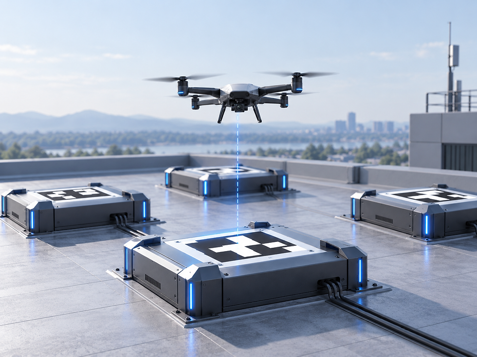
Autonomous landing does not end when the drone reaches the general area. The aircraft still has to maintain reliable visual reference to the landing marker and confirm that it is approaching the correct designated dock.
RangeMark is designed to support continuous marker sighting across distance and approach, while providing a unique machine-readable identity for each landing point.
That matters in environments with multiple docks, moving docking stations or autonomous fleets, where simply recognizing a landing marker is not enough.
See the marker. Identify the dock. Stay locked through approach.
.png)
FIXED DOCKING STATION
.png)
MOVING / MARITIME DOCKING
.png)
FLEET DOCKING
.png)
MULTI-DOCK ENVIRONMENTS
PLATFORM INTEGRATION
Build RangeMark into the autonomy stack.
RangeMark is designed to integrate into the platforms that power autonomous drones — including onboard compute, vision, autonomy software and flight-control systems.
Rather than relying on one-off integrations with individual aircraft, the capability can be supported at the platform level and reused across multiple systems and applications.
Precision landing provides the first integration use case. From there, additional visual-identity applications become easier to activate.
We work with platform and technology partners to define the right integration path for their architecture and workflows.
RangeMark Inside. One integration, multiple autonomy use cases.

BUILT FOR THE AUTONOMY CURVE
Built for today’s operations — and tomorrow’s autonomy.
Drone autonomy is a progression.
Drone operations span a range of control models, from operator-led missions to increasingly autonomous systems.
RangeMark supports today’s remote and assisted workflows by providing a reliable visual identity reference to designated assets, locations and endpoints.
As autonomy advances, that same capability remains relevant inside the stack — helping systems confirm exactly which marked object or location they are acting on.

One identity layer. Relevant across the autonomy curve.
Follow what comes next.

See how RangeMark is advancing long-range visual identity for autonomous systems — from ongoing validation and platform integration to new applications as the market evolves.